The Elwha River, which flows south to north through the interior of the Olympic Peninsula, has long been a popular attraction for backpackers.
But when Craig Romano and I planned the second edition of Hiking Washington’s History, we had to omit one of my favorite trails along the river–to the lookout at Dodger Point. There, during World War II, Leith and Mary Johnson watched for enemy planes that might be heading to Boeing or the shipyards of Puget Sound. They were on duty 24 hours a day, seven days a week, during the summer of 1943.
Fifty years later, after Leith died, Mary visited all seven lookout stations where she and Leith had served in the early 1940’s. At the age of 79, she carried a 25-pound backpack 14 miles and 5000 feet of elevation gain to Dodger Point.
Even more years later, Mary met me at the Whiskey Bend campground the night before my own hike to Dodger Point, sharing hot dogs and beans around a campfire and telling me stories of her years in the Olympics. She and Leith were the human interest focus for the Dodger Point hike in the first edition of the guidebook.
Now, the hike to Dodger Point is even more daunting. The free-running Elwha River has washed out the road to Whiskey Bend and the campground, adding a 6.2 mile hike (instead of a drive) to the trailhead. After years of advocacy for removal of two dams on the river and an act of Congress, the Glines and Elwha dams were removed from the river in 2012 and 2014, allowing salmon to return to spawning grounds they had not reached for a century since the dams were constructed to provide power in 1913 and 1927. Soon the salmon returned, but the hikers did not return in force.

Less than a year after the second dam was removed, November 2015 rains washed out 90 feet of the main access road to the Elwha River trailheads. The National Park Service made a temporary repair and bridge, at a cost of $450,000, which opened in January 2017, then closed again in February. November 2017 rains washed out the road again with water that peaked at 18,000 cubic feet per second, a surge that rose to the roadway and tore slabs of pavement away.
So we took Dodger Point out of the second edition, but we didn’t have the heart to take out another hike, the route of a Seattle newspaper-sponsored expedition into the heart of the Olympics in 1889. We just noted that you have to hike more miles to get to the Whiskey Bend trailhead. The men of the expedition spent two months getting to that point from Port Angeles and their whiskey was “pretty well exhausted.”
This March I was curious to hike some of those miles to the trailhead, without whiskey and in one day, to see the changing course of the Elwha. My husband Al and I walked the Olympic Hot Springs Road 3.4 miles not to Whiskey Bend but to the Glines Canyon overlook where the second dam on the Elwha was removed.
The hike to the overlook is easy. It begins at the trailhead for Madison Falls, where there is parking, an outhouse, and an attractive waterfall. Walk around the gate on the road and begin walking in open country on pavement. About one mile in is the washout and a bypass trail leading around the washout
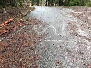
along the east side of the river. After a sometimes slippery, sometimes muddy half-mile, you’re back on pavement with a view of the washout from the other end.
From here the paved road leads through the Elwha Ranger Station, a series of locked, wooden frame buildings with an aura of lost vibrancy. Despite the usual government brown signs, the restrooms are closed, too; they are not easy to service without a road. 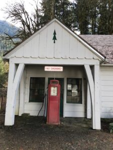 A dirt road cuts off to the left, marked to the Whiskey Bend trailhead, the jumping off point for both the Dodger Point and Press Expedition hikes. I was wistful but not prepared for backpacking. Instead, we continued toward the overlook. After that turnoff, the paved road crosses the river on a bridge, a welcome amenity, winds past the closed Altair picnic area, and then climbs past a speed limit sign of 25 miles an hour and an unnecessary warning that RVs and trailers are not suitable from this point on. Two cyclists careen down as we plod upward.
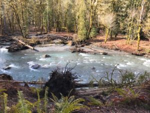
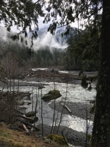
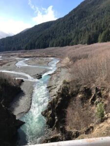
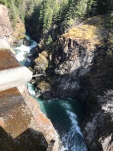
At a bend in the road, a secure sidewalk leads to a stunning view deep into the canyon where a dam once stopped the Elwha River and backed it into Lake Mills, flooding approximately 438 acres of river and land. To the north, the river rushes through the remnants of concrete walls on the sides of the canyon. To the south of the overlook, the Elwha cuts a new course through the wide expanse of what was the lake bottom.
For an explanation of the revegetation work there, see National Park Service and Lower Elwha Klallam Tribe’s Revegetation and Restoration Plan for Lake Mills and Lake Aldwell. Again, the bathrooms are closed, but interpretive plaques explain what transpired here.
The road continues on another 4.4 miles to the Olympic Hot Springs, which feature 21 seeps from the ground, hence the name of the road. But you have to walk or bike there, and the springs are “unmaintained.” We turned around.
It felt strange to be walking down a road and not hear the sound of approaching cars but the constant swift current of a river.We encountered few others on this route—the couple biking down from the overlook, a family of three hiking the same direction as us, and an Americorps crew returning from revegetation work in the old Elwha campground, which was also washed out. We stepped aside on the narrow bypass trail for the last guy in the group who carried a car battery in a sling on his hip; they had hoped, vainly it seemed, to use one of the vehicles trapped at the Elwha Ranger station for transporting plants. They piled helmets, work tools, the battery and tired bodies into a van on the north end of the bypass trail.
To make the road and trailheads into the northern Olympics more hiker-friendly again, the National Park Service is working on an alternate route for the road, away from the floodplain, avoiding another surge from the newly freed Elwha. A 2019 Environmental Assessment report presented three options: no action to repair the road, modifying the current road alignment to raise grade, or a reroute of one mile of the road outside the floodplain. As of Spring 2023, the environmental compliance process was not complete. So for now, it’s still a long hike to trailheads–not a drive–but a rewarding walk in itself.