Snoqualmie Tunnel: A cool surprise

When Seattle historian and journalist Bill Kossen told me about his experience on the Iron Horse Trail, I invited him to write a post.  As a Northwest native, he has some “cool” history to share:

It was a balmy, early fall day on Snoqualmie Pass and the sprawling parking lot at Iron Horse State Park was nearly empty. Good sign. I was on a mission and didn’t want to be surrounded by a lot of masked and unmasked people. Nearby Alpental was crawling with hikers.  I just wanted to see, and possibly hike through, the former railroad tunnel that I read about in Hike 18 of Judy Bentley’s excellent Hiking Washington’s History.

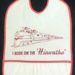
Didn’t know what to expect. The tunnel is hidden from view from the parking lot near the Hyak ski area (now called Summit East) and has a fascinating history that borders on the mystical, thanks to the book. The tunnel and ski area also has a strong, personal pull on me. One of my earliest memories is of taking the Milwaukee Road Olympian Hiawatha train as part of a family trip to the Midwest back in the summer of 1958 when I was only 3. The train went through the tunnel, but I don’t remember that, just the excitement on being on the rocking, rolling train and getting a souvenir “I Rode On The ‘Hiawatha’ ” bib in the dining car. One of these days, I might frame that bib.
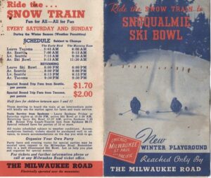
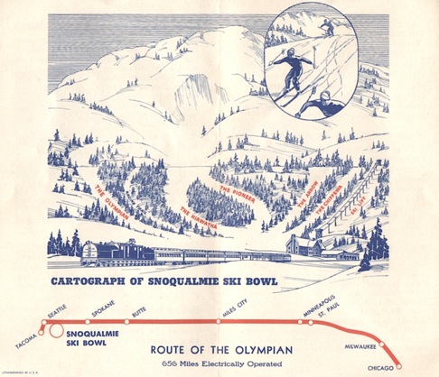
From my parents, I inherited a 1940s brochure about the “Snoqualmie Ski Bowl” and the Milwaukee Road’s “Snow Train” that took them there, dropping them off at a ski lodge after exiting the tunnel.   Mom told me about it, but the train and the “Ski Bowl” were long gone by the time I began skiing in the early 1960s. Things had changed dramatically at Snoqualmie Pass by then. were three ski areas instead of one and plenty of chairlifts and rope tows instead of none. My parents wanted me to learn as they did, so for the first few trips, they wouldn’t pay for a lift ticket. I had to climb the hill with my skis on, clomping along in herringbone style while the other kids whizzed by on the lifts. That was OK; I learned to ski uphill, too.  
Those memories flooded back as I got out of the car. The temperature in the parking lot was 70, so I put on a light jacket and set out for a half-mile hike on a level, well-maintained gravel trail to whatever was waiting around the bend. A few minutes into the hike, I felt a refreshing, cool breeze. Figured there must be an icy creek or pond hidden nearby. But all I could see were trees and brush alongside the trail. Then as I rounded the bend, the breeze picked up and went from cool to chilly. The reason was looming ahead, the colossal opening to the Snoqualmie Tunnel, a huge and quiet air conditioner.
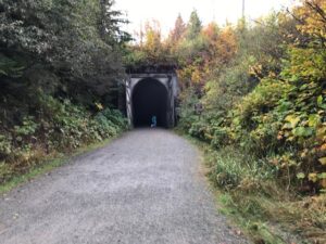
A lone biker passed me, switching on his headlamp, and disappeared into the tunnel. Two hikers with a small dog entered the tunnel, too. Tentatively. They stopped after going a few feet and snapped a few pictures while the dog stared at me. Even the pet appeared in awe. I kept my distance until they left and then entered the tunnel, past the ancient wooden doors so huge they could protect a castle. I had hopes of hiking and running to the other end, a little more than 2 miles away, until I turned on my headlamp and two handheld flashlights that suddenly felt very tiny. My, was I unprepared. The darkness sucked up the light like nothing I had ever seen.

But I hung around in the dark silence for a few minutes just to take it all in. Would I hear echoes of the hundreds of tunnel workers who chipped and blasted their way through the rock a century ago?  Would I see a ghost train roll by illuminating the pitch-black tunnel? The book had triggered my imagination. Hike 18 ended with this suggestion to those hiking from the other end of the trail (or closer starting points), 21 miles away on the west side of Snoqualmie Pass: “To relieve the long miles, imagine the headlight of an orange and black locomotive of the Olympian Hiawatha, carrying revelers high over the creek ravines, through the long dark tunnel, along the river canyons, and into the bright sunlight at the peak of the Cascades.”  It worked. I’m hooked and now looking forward to hiking to the tunnel from the other side, where you get to cross trestles high above those creek ravines and have a better chance of seeing that historic headlight. What a cool trek.
Eruption of Mount St. Helens

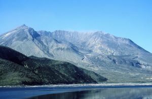
When our family visited Washington in August 1980, there were masks hanging in the garage of the house we rented.  They were a hold-over from the eruption of Mount St. Helens just a few months before (and perhaps a foreshadowing of our life in Seattle during the pandemic forty years later).  We moved out from New York City in January the next year and began to hear the stories of where everyone had been when the mountain erupted.  Here’s a new one I hadn’t heard from Gary Rose, friend of my good friend and writer, Joan Burton:  
 
“Forty years ago tomorrow at approximately 8:30 am two close friends, Dave and Maxine Nicholson and myself, were on our skis headed to Camp Muir located at the 10,000 ft, level on the south side of Mt. Rainier to enjoy a great day of spring skiing.  We were hoping to find a rather rare condition called “Corn Snow” found in almost no other area in the U.S. except the Cascades and sometime the Sierras.  It occurs in the spring time and  is caused by the freezing and thawing cycle, giving the snow surface a unique consistency that skiers “Die” for.
 
We left Paradise early and were near the 8,000 ft. elevation level on a beautiful cloudless morning.  Having just stopped for a short rest and bite to nibble on, we were putting on our skis when we noticed Mt. St. Helens, some 30 miles to our southwes,t blowing hot ash high into the air from it north side.  At first we assumed it was “showing its stuff” as it had done a couple of times in the last few weeks.  We resumed our climb upwards towards  Camp Muir keeping an eye on the growing ash cloud coming from St. Helens.  Within 10-15 minutes the black cloud had grown to an estimated 60-80,000 ft.  (15 miles) into the sky above the mountain and was drifting NE in our direction.  At no time did we hear a rumble or explosion which was heard in Seattle and as far north as Bellingham.  Our first indication that maybe we should forget Camp Muir was when we noticed lighting strikes between the approaching dark super heated ash cloud and the ground below.  I had experienced lightning storms before while on the Muir snowfield and for sure, it is not a place one wants to be in a electrical storm.
 
With haste we scrapped the idea of Muir, pealed off our climbing skins, adjusted our binding to down hill mode and made a few turns in ideal spring corn snow.  A few hundred feet below, the first rain drops hit us and the snow immediately took on a grey/brown color.  Each raindrop uncased a blob of ash and soon our clothes were sopped wet and covered in grey ash.  To add to our misery all of a sudden it was like our skis hit sand paper and they would not slide.  Snow and ash built up and stuck to the bottoms of our skis.  We took them off, tied them to our packs and proceeded post-holing on foot  towards the parking lot at Paradise.  Finally we staggered into Paradise to find a couple of inches of ash all over everything, cars, buildings, trees, everything!  The Park Rangers were going ballistic.  All uphill traffic had to be stopped at the park entrance and Rangers were making up car convoys of park visitors headed by a Ranger Patrol vehicle with flashing lights.  We, along with every one else, were  shuttled  down the mountain and out of the park.  About 10 miles west of the National Park we drove out from underneath the black cloud and into the sunshine.
 
Photos?  To save weight not one of  us carried a camera that day.  You will just have to believe my story.  Fifty seven people died in the eruption, 1,300 feet of the top of St. Helens was blown off and millions of trees blown over and destroyed.

Lost and Found in History

            As often happens in the writing life, authors may be immersed in a new book but recalled to another.  That was the case with Free Boy: A True Story of Slave and Master this week when I was interviewed by Rob Smith for his podcast welcometoolympia.com, which showcases stories from Olympia, Washington. 

            The free boy in question, Charles Mitchell, lived in Olympia from 1855 to 1860 when he escaped on a mail steamer to Victoria Island in what is now British Columbia.  Mitchell was 13, a child of mixed race, living in the household of James and Isabella Tilton, and owned by them.  Slavery was legal in Olympia because territories did not have the right to declare themselves slave or free.  James Tilton was the Surveyor General of Washington Territory, an important job mapping the new territory so that incoming settlers could claim land.  Tilton brought the young boy to Olympia from a plantation in Maryland owned by Tilton’s mother’s family.  Mitchell’s father was an unknown white man, and his enslaved mother died of cholera when the boy was three.  Tilton promised to educate Charles, to train him for a job as a ship’s steward, and to free him when he turned 18.

            When given the chance to be free before then, Charles didn’t wait.  He was encouraged and aided by free blacks in Victoria who visited Olympia and by James Allen, the cook on board the steamer.  Allen hid Charles in the lamp room, and although he was discovered on board before the Eliza Anderson docked in Victoria, he was brought off the boat through a writ of habeas corpus and declared a free boy by a British judge. This was his moment of fame.  And then he vanished into history, after a brief appearance in a school for boys.

            That was the story Lorraine McConaghy and I wrote in Free Boy, published by the University of Washington Press in 2013, an inspiring story of a young boy yearning for freedom and the Victoria blacks who engineered his freedom.

            But then what?  The Civil War began months after Mitchell escaped, and by its end in 1865, he would have been free.  Did he ever come back to the United States?  Did he ever find his father or family in Maryland?  Did he have a successful life?  Lorraine and I did not know when we finished the book.  We could only speculate about which of many Charles Mitchells he might have been in the Pacific Northwest. 

            In fact, Mitchell roamed farther than we thought.  Inspired by his story, a researcher dove into the mystery.  With only Mitchell’s name, race, place of birth, and approximate birth date, Thomas Blake delved into census tracks, voter records, city directories, pension applications, marriage and death certificates.  He found that:

  • Mitchell returned to the United States right before the end of the Civil War and enlisted in a California infantry company that was stationed at Fort Stevens at the mouth of the Columbia River, named after Isaac Stevens, the first governor of Washington Territory—and a friend of James Tilton’s.
  • After that Mitchell worked as a ship’s steward, a cook, waiter, and all-around crew member, the job he had been trained for, on ships based in San Francisco.
  • He married twice, first to a mulatto woman named Elsie L. Browne.  They had a son, Charles, born in May 1870.  She died in 1885; the fate of their son Charles is unknown. 
  • At the age of about 40, Mitchell married a young white woman named Sarah Frederick in Liverpool, England.  Mtichell brought Sarah back with him to the United States, along with his mother-in-law, and they had seven children, four of whom lived to adulthood.  Their household in San Francisco was variously described as white or mulatto. 
  • He broke both knee caps in falls related to his work.  He also broke both ribs in the San Francisco earthquake of 1906, injuries that eventually earned him an invalid pension from the military.
  • He died in 1910 in the Veterans Home of California in Yountville, at the age of about 60. 
  • He has no known living descendants.  His one known grandchild died in 1999 in Paradise, California and had no known children.   

            In some ways, Charles Mitchell lived a fairly ordinary life.  He married, had children, and worked hard at physical jobs that left him partially disabled.  His adult life as a free man was not as dramatic as his brief moment of fame as a youth, but his work as a mariner took him around the world, and he briefly enlisted in the cause he had left Olympia for, the cause of freedom for youth like him.  His courage at 13 earned the right to determine his own life.

Yakama-Cowlitz Trail

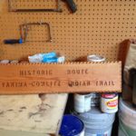
This sign sits in my garage in West Seattle, a gift I don’t quite know what to do with.  It was given to me by the folks at the White Pass Country Museum in Packwood, Washington, when I was researching the Yakama-Cowlitz Trail.  I suspect one reason it was “surplus” was the spelling of the name Yakima–which is the spelling for the city but not for the people.  It was also a nudge–finish that article on the trail!  So I did.

This summer’s issue of Columbia, published by the Washington State Historical Society, features my article on the Yakama-Cowlitz Trail to Cowlitz Pass, a trail taken for thousands of years by people from both sides of the Cascade Mountains.  Cowlitz Pass stands just southeast of Mount Rainier, on the Pacific Crest Trail.

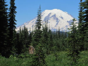
Mount Rainier visible from Cowlitz Pass

During the winters some Yakama people lived in the Tieton and Naches River valleys on the east side of the Cascade Crest.  The Cowlitz lived in the Big Bottom of the Cowlitz River on the west. In the summer months, the Yakama came up what is now Indian Creek from the east side; the Upper Cowlitz or Taytnapam came up Summit Creek from the west side.  They hunted deer and mountain goats, gathered huckleberries, and socialized.

Gradually, through intermarriage, the Taytnapam acquired some characteristics of the Yakama, in language and dress.  In years after American settlement, they continued to cross the pass to visit relatives.

I found out about this trail through the writings of archaeologist David Rice, the work of Gifford Pinchot anthropologist Rick McClure, and the advocacy of Ray Paolella for the William O. Douglas Heritage Trail.  As a youth, Douglas hiked up to Cowlitz Pass and spent time with the sheepherders there.

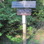
Efforts are afoot to map some 23 miles of this historic trail.  The last four miles from the west are Forest Service trail #44 which begins from the Soda Springs campground where the real sign is posted.  It’s a wonderful day hike or backpack, but beware of mosquitoes until late summer.

Kettle Falls

When I visited the site of Kettle Falls while researching Hiking Washington’s History, I had read the description by Mourning Dove of her family’s visits to the “roaring waters.” The traditional fishing site, where many tribes gathered in the summer to catch salmon, is now buried under Lake Roosevelt, created by the damming of the Columbia River.

Last winter, I met Lawney L. Reyes at an authors’ night at Island Books.  He was clearly the oldest author there, and I bought his book, White Grizzly Bear’s Legacy.  Just a month or so ago, I met his nephew on a bike ride in West Seattle, and returned to the book.

Reyes, too, wrote about Kettle Falls, where his people, the Sin Aikst, once fished.  The Sin Aikst are now known as the Lakes tribe and have been absorbed into the Colville Confederated tribes.  Reyes describes the tribes gathering in June.  “As a boy, I would stand in wonder as the chinooks, some more than a hundred pounds in weight, leaped the churning falls…. I still recall the roar of the falls and the voices of the people shouting instructions to each other.  I’ll never forget the beauty of the hundreds of tepees of the different tribes.  They lined the shores of the river close to the falls.  There were horses and people everywhere.”

Kettle Falls was once the center of Sin Aikst culture.  Reyes quietly and poignantly tells the story of the loss of this food source and history when the dam was completed in 1942.

Coal Creek to Redtown Trail

See my article on this hike, “Find a Trail to History,” in the October 2017 issue of Northwest Prime Time.

The Coal Creek trail to Redtown, site of industrial mining in the late 1800s, was the first hike I did in Washington and the inspiration for Hiking Washington’s History.  I could walk out of my suburban home, follow a social trail down a hill, then a deer trail through wet land to Coal Creek. Coal Creek Trail The trail followed the creek, past an old farm-site (with apple trees), past mining artifacts (wagon wheels chained to a tree, chunks of coal), onto the old road-bed of the Seattle and Walla Walla Railroad, past a cinder mine and the remains of the railroad turn-table, and finally reached Redtown.  Near the end of the hike there were old interpretive signs and a black hole in the ground–an air shaft going down 100 feet to the mines.  Coal CreekThe trail was rich in both natural and human history.

In the 30 years since my first hike King County has greatly improved the trail, part of the Cougar Mountain Regional Wildland Park.  Updated, easy to read interpretive signs mark the Redtown end of the trail.  Bridges and stairs have been constructed.  The Primrose loop has been restored.

The most important charms remain–the concrete blocks of the turntable covered with fall leaves, the North Fork falls full in October, the remains of a wood-constructed plume in the creek and the visible coal seam, even the bricks discarded from the Mutual Materials lot, now a housing development.  You can still walk this three-mile trail, out of sight of homes or parkways, and be greeted by this weathered sign, an historic artifact on its own.  Coal Creek sign

Oregon Trail markers in Washington

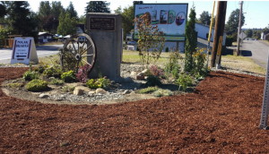
There are now fourteen Oregon Trail markers in Washington (see comment below), marking Oregon Trail markerthe Oregon Trail cutoff to Puget Sound.  In Washington the Oregon Trail followed the Cowlitz River from Fort Vancouver to Cowlitz Landing, then went overland on a rough wagon road to Olympia. There are markers at Vancouver, Woodland, Kalama, Kelso, Toledo, Mary’s Corner, Centralia, Grand Mound, Tenino, Bush Prairie, Tumwater, and Olympia, the end of the trail on south Puget Sound.   The trail marker pocket park in Toledo, maintained by the Daughters of the American Revolution, Sacajawea Chapter,  has been restored and was rededicated in 2016.

Everett’s Weyerhaeuser Building

A hiking and walking friend, Linda Paros, alerted me a few weeks ago that the ornate Weyerhaeuser building in Everett was up on moving blocks.  What’s up? she asked.  The Seattle Times and the Everett Herald had the answer in mid-July.  It’s moving–again.

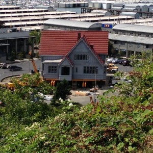
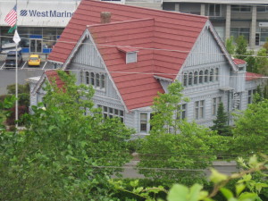
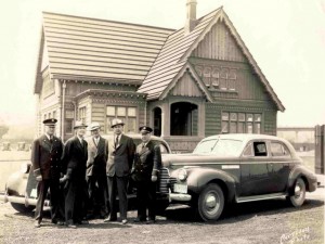
Weyerhaeuser buildingThe 93-year-old structure first sat at the foot of Pacific Avenue near Weyerhaeuser’s Mill A, the largest lumber mill in the world when it was built in 1912.  Although Weyerhaeuser headquarters was in Tacoma, near the Northern Pacific Railroad, from which Frederick Weyerhaeuser had bought timberland, the company’s largest mills were in Everett.  The local office building was designed by architect Carl Gould in a Gothic style to showcase local wood products from fir, cedar, and hemlock.  Fifteen years later it was barged to sit near Mill B on the Snohomish River.   After Mill B closed in 1979, the office moved again in 1984 to Marina Village to house the Everett Chamber of Commerce near the city’s newer economic enterprise, the U.S. Navy’s Homeport.

It will move this year to a development in the Port of Everett’s Central Marina, retaining its historic claim to the waterfront.  If nothing else, the building has showcased the strength of its structure.   The building is included in the Everett chapter of Walking Washington’s History: Ten Cities.IMG_1960

L_Weyerhaeuser_Office-640x480

historic murals

Main Street Moments

In writing Walking Washington’s History: Ten Cities, I chose a moment of significance for each city.  See Main Street Moments, a photo essay on the University of Washington Press Blog.

Each city had at least one moment when it was significant in the history of Washington Territory or the state.

Vancouver started as a fur-trading post in 1825, commanding a vast empire from Alaska to California.

Olympia, at the Washington end of the Oregon Trail, became the territorial capital in 1854 and fought off rival cities until statehood in 1889.

Walla Walla boomed on mining rushes to claim the title as largest city in the territory in the 1860s and a rival to Olympia for the capital.

Tacoma won the terminus of the Northern Pacific Railroad and boomed for two decades in the 1880s and 1890s.

Seattle boomed as a jumping off point for the gold rush in the Yukon.

Everett’s corporate titans and labor unions clashed in the early 1900s.

BellinghamBellingham’s four-towns city emerged from logging, mining, railroads, canneries and a university.

Yakima marketed the riches of the Yakima Valley.

Spokane reclaimed downtown and the river running through it with Expo ’74.

Bellevue changed from a suburb to an edge city.

The Chinese at Coal Creek

History is never finished and done, in the past.  The writing of history brings new revelations about the history that may not yet have been told, that has been intentionally neglected, usually the more shameful events from the past.  When I wrote about the Coal Creek Trail in Hiking Washington’s History, I knew there were Chinese miners at this site in a Seattle suburb, but I did not know the full story.

R. Gregory Nokes writes about the burning of the homes of 49 Chinese miners near the Coal Creek mines in 1885 in his book Massacred for Gold.  The book also recounts the killing of more than 30 Chinese gold miners on the Oregon side of Hells Canyon in 1887.  The source of the information about Coal Creek is a Statement of Claims prepared by Chang Yen Hoon, the head of the Chinese legation in Washington, D.C.  Chang sought compensation for various acts of violence against Chinese immigrants in the U.S., including losses of $4,054.88 from the Coal Creek Mine in Washington Territory.

That wasn’t the first such incident at Newcastle.  In 1876, 40 Chinese mine workers were driven from the same mines, according to a coal miner who wrote to his wife:  “The miners at the Seattle mine [at Newcastle] drove all the Chinamen away from there Saturday last” (quoted in Historylink.org Essay 219).

The name China Creek lingers in contemporary Bellevue near the site of the Newcastle mines.  It is most often associated with a trail, a housing development, and the Golf Club at Newcastle, with no mention of the source of the name.  Ironically, the golf course at Newcastle has recently been purchased by a Chinese company.