Snoqualmie Tunnel: A cool surprise

When Seattle historian and journalist Bill Kossen told me about his experience on the Iron Horse Trail, I invited him to write a post.  As a Northwest native, he has some “cool” history to share:

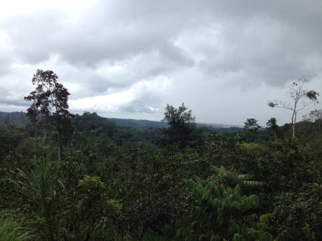
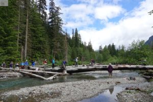
It was a balmy, early fall day on Snoqualmie Pass and the sprawling parking lot at Iron Horse State Park was nearly empty. Good sign. I was on a mission and didn’t want to be surrounded by a lot of masked and unmasked people. Nearby Alpental was crawling with hikers.  I just wanted to see, and possibly hike through, the former railroad tunnel that I read about in Hike 18 of Judy Bentley’s excellent Hiking Washington’s History.

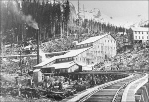
Didn’t know what to expect. The tunnel is hidden from view from the parking lot near the Hyak ski area (now called Summit East) and has a fascinating history that borders on the mystical, thanks to the book. The tunnel and ski area also has a strong, personal pull on me. 
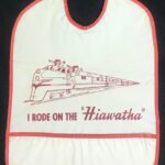
One of my earliest memories is of taking the Milwaukee Road Olympian Hiawatha train as part of a family trip to the Midwest back in the summer of 1958 when I was only 3. The train went through the tunnel, but I don’t remember that, just the excitement on being on the rocking, rolling train and getting a souvenir “I Rode On The ‘Hiawatha’ ” bib in the dining car. One of these days, I might frame that bib.

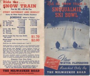
From my parents, I inherited a 1940s brochure about the “Snoqualmie Ski Bowl” and the Milwaukee Road’s “Snow Train” that took them there, dropping them off at a ski lodge after exiting the tunnel.   Mom told me about it, but the train and the “Ski Bowl” were long gone by the time I began skiing in the early 1960s. Things had changed dramatically at Snoqualmie Pass by then. 
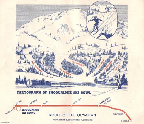
were three ski areas instead of one and plenty of chairlifts and rope tows instead of none. My parents wanted me to learn as they did, so for the first few trips, they wouldn’t pay for a lift ticket. I had to climb the hill with my skis on, clomping along in herringbone style while the other kids whizzed by on the lifts. That was OK; I learned to ski uphill, too.  

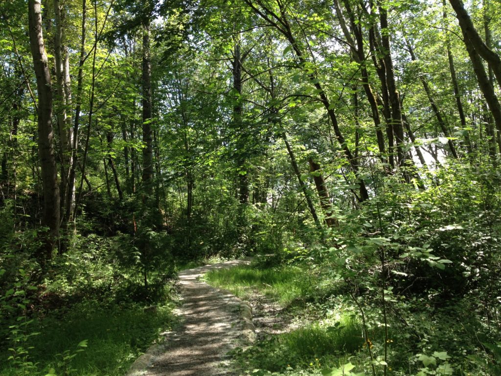
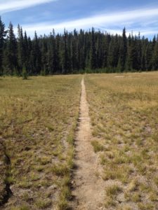
Those memories flooded back as I got out of the car. The temperature in the parking lot was 70, so I put on a light jacket and set out for a half-mile hike on a level, well-maintained gravel trail to whatever was waiting around the bend. A few minutes into the hike, I felt a refreshing, cool breeze. Figured there must be an icy creek or pond hidden nearby. But all I could see were trees and brush alongside the trail. Then as I rounded the bend, the breeze picked up and went from cool to chilly. The reason was looming ahead, the colossal opening to the Snoqualmie Tunnel, a huge and quiet air conditioner.

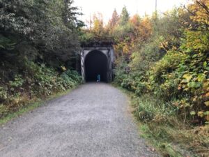
A lone biker passed me, switching on his headlamp, and disappeared into the tunnel. Two hikers with a small dog entered the tunnel, too. Tentatively. They stopped after going a few feet and snapped a few pictures while the dog stared at me. Even the pet appeared in awe. I kept my distance until they left and then entered the tunnel, past the ancient wooden doors so huge they could protect a castle. I had hopes of hiking and running to the other end, a little more than 2 miles away, until I turned on my headlamp and two handheld flashlights that suddenly felt very tiny. My, was I unprepared. The darkness sucked up the light like nothing I had ever seen.

But I hung around in the dark silence for a few minutes just to take it all in. Would I hear echoes of the hundreds of tunnel workers who chipped and blasted their way through the rock a century ago?  Would I see a ghost train roll by illuminating the pitch-black tunnel? The book had triggered my imagination. Hike 18 ended with this suggestion to those hiking from the other end of the trail (or closer starting points), 21 miles away on the west side of Snoqualmie Pass: “To relieve the long miles, imagine the headlight of an orange and black locomotive of the Olympian Hiawatha, carrying revelers high over the creek ravines, through the long dark tunnel, along the river canyons, and into the bright sunlight at the peak of the Cascades.”  It worked. I’m hooked and now looking forward to hiking to the tunnel from the other side, where you get to cross trestles high above those creek ravines and have a better chance of seeing that historic headlight. What a cool trek.

Hiking in Ecuador

Because I write about hiking in Washington State, and there is plenty of that to do, I rarely cross the border into Oregon or Idaho, even less to Canada.  I have hiked briefly in Norway and Switzerland, “trekked” in Vietnam (really just a short walk), and visited southern Africa, but I don’t consider myself an experienced international hiker.  All the more reason that, on a recent trip to Ecuador, a hike in the Amazon stretched my comfort zone.    

The Amazon is a broad topic—a watershed of almost three million square miles spanning eight countries.  Its tributaries flow into the Amazon River from the Andes on the western edge of South America to the Atlantic Ocean on the east.  I hiked one mile in the Oriente section, near the Rio Napo, a broad, brown, slow-moving tributary that begins on the Cotapoxi volcano and flows 550 miles to the Amazon. 

This sampling of the jungle began with a machete. Wielded in the strong arm of our young guide Alfonso Jimenez, the machete was not to stave off snakes or jaguars or other hostile hikers but to keep vines and encroaching palm leaves at bay—the usual trail-clearing and upkeep.  More important were the rubber knee-high boots we all tucked into to protect from mud and insects. 

Our open safari excursion truck stopped along the side of a rocky dirt road with no trailhead in sight. We were seven eco-tourists, young and old, in a rainforest preserve supported by the Fundacion Yachana.  The foundation also supports the Yachana Parque de Ciencias, an education center envisioned and implemented by Douglas McMeekin.  Yachana, an indigenous Kichwa word, means “a place for learning.” 

Alfonso, a graduate of that program, led us across a shallow ditch with trampled vines and ferns and paused for a brief safety orientation.  We were not to grab hold of tree trunks inhabited by large ants, nor should we linger crossing fire-ant hills.  He pointed out one exotic bug which spitefully bit him but not us.  Other than that, the dangers would be limited to those vines, both hanging and underfoot. 

As soon as we were beyond the sunshine of the road, the trail underfoot was easier to follow, sheltered from exuberant growth by the canopy.  As Alfonso swung left and swiped right, I maintained a respectful distance.  He pointed out the strangler figs which root from animal droppings in trees. They start at the top of a tree, seeking light, then grown down. They are somewhat similar in their action to the invasive ivy of the Pacific Northwest, but unlike ivy, these vines survive to become a tree.  Once the roots reach the ground, they strangle the host tree and may or may not kill it.  The walking pine tree has a similar standing cone of roots. 

Walking pine

We couldn’t help but notice the giant ceiba pentandra, better known as a Kapok tree.  Kapok is the cotton-like fluff obtained from its seed pods which used to be fill for life jackets, mattresses, and pillows until artificial alternatives were produced in the 1940s. The tree matches in exotic appeal the baobab trees of Africa and the giant cedars of the Olympic rainforest.  I marked the kapok’s huge buttress roots as a potential refuge, a good tree to stay put with. 

The fear of getting lost in the rainforest, similar to the dark forests of the Northwest, is real. There are few breaks in the canopy—only when a tree falls down and creates an opening—and the dense vegetation underneath quickly obscures little-used trails.  The casual hiker is dependent on someone else’s trail maintenance.  But this hike was without hazard except for one final vine reaching out to ensnare a dragging foot.  The climatic drama came after the hike–racing a torrential rain-storm back to shelter. 

A later night walk with flashlights revealed more exotica—tree frogs, pond frogs croaking loudly the whole night long, spiders including the tarantula, salamanders, cucarachas, and the more familiar bugs like katydids and grasshoppers. 

Hiking for pleasure is a foreign concept to the resident of the Amazon and hiking for fitness would be self-defeating.  The object in life closer to nature is to conserve energy and spend it wisely. For centuries, transportation has been by river; you can see where you are going and where you might come out.  Walking comes with a purpose: to harvest grapefruit or heart of palm on a farm, to carry a bag of lemons or a baby with you to the bus-stop and the market. Schoolchildren at recess gazed curiously at these gringos trudging down the road in the sun after our truck runs out of gas.  Our companions on hikes and biking adventures were mostly European—from Norway, England, Lithuania, Germany, and France.

On the same trip, we also hiked to a waterfall near Mindo, west of Quito, a trailhead reached by a cable car ride over a deep valley.  To reach the cable car station, we could either ride on a ski lift type chair or climb up a relatively short but steep mountain.  Leery of heights I can’t attain on my own two feet, I chose the hike, which added meaning to the phrase “catching your breath.”  The waterfalls are like waterfalls everywhere, but the birds, insects, and wildflowers out-color even a Cascades meadow in full wildflower.  The reds are redder, the pinks are rosier; one bird can display a rainbow. 

From Mindo, we traveled east to the highlands and biked down Cotopaxi, one of the world’s highest volcanoes at more than 19,000 feet. We started at more than 14,000 feet, high enough. (The top of Mt. Rainier is 14,411 feet.  Sunrise, where trails on the slope are accessible by auto, is at 6,400 feet, about the highest I’ve ever gone). At a similar elevation, more than 12,000 feet, we hiked around a caldera–an Ecuadorean counterpart to Oregon’s Crater Lake–at Quilotoa.  In the highlands, we were hiking for views and solitude, which also seems a foreign concept in Ecuador.  Life is nothing if not communal, and the highlands can be cold, windy, barren, and hostile.  One arrives, has an adventure, and leaves.  The thin air challenges even the most fit. 

Biking down from the Cotopaxi volcano, Ecuador

The human universal between hiking in the Pacific Northwest and in Ecuador?  A connection through the land to the ancient past.  On the slopes of Cotopaxi, on a hillock elevated from surrounding plains, we found Inca ruins.  Restored rock walls and a thatch hut recall the 40-year period of Inca domination in Ecuador in the late 1400s before the Spanish invaded in 1532. This was a place from which you could see for miles–see your enemies, see game–and shelter down the hill. Despite the threatening volcano, humans have made an imprint on the land for thousands of years.

Inca ruins

Wild and safe?

In 35 years of hiking all over the Pacific Northwest, I have not feared those I meet on trails.  Any one who hikes miles and climbs mountains is probably not intent on crime.  I trust fellow hikers’ motives for being there.  We are all testing ourselves against nature, enjoying solitude and the oxygen high that comes from pure air and rushing streams.  In the decades of my 50’s, 60’s and 70’s, I have ventured out alone as needed to research hikes for Hiking Washington’s History.   Physically, I’m no match for a bigger, stronger protagonist with a gun, but those are not the people I encounter on trails.  They’re more likely to be a group of retirees enjoying relative hiking freedom and solitude on a Tuesday.  I have also hiked for eight hours in southeastern Washington and encountered only foxes and elk.  My biggest concern has been whether my car would break down on a pot-holed Forest Service road. 

            The story is different in city and suburban parks.   When I lived in Bellevue, a suburban city in Washington, my favorite trail was in Cougar Mountain Regional Wildland Park, near my house.  My daughter and I regularly ran a one-mile or so loop through the park.  We had moved here from New York City and thought the park was a truly wild land, a place with no houses in sight and trails going off in many directions.  To run or hike there was to escape from any tensions a comfortable life created—

            Until I learned that a teenage girl had chosen the park as the place to end her life, near a waterfall.  I could not run or walk there again without thinking that to this girl it was a place she could be away from people who might have tried to save her, a kind of solitude that is not healthy.   

Trail in the West Duwamish Greenbelt

            We moved a few years later from Bellevue to Seattle where I have been active in the West Duwamish Greenbelt Trails group, which promotes hiking in the largest contiguous forest in Seattle.  The 500-acre greenbelt on a ridge above the Duwamish Waterway is bordered by houses, a community college, and an elementary school.  Our goal as a group is to encourage people to use the maintained trails in the greenbelt.  We want people to feel at home in the forest, within a few minutes of city life.   Urban parks can be a haven—a place to get away from social pressures of congested living; a place to hear birds, find mushrooms, even watch ducks on a pond, a place to be alone without relating to others. 

            The natural threats in the greenbelt are few. Cougars roamed the ridge above the Duwamish River centuries ago but no more.  Strong winds may fell trees across the trail, but windy days can be avoided. Human threats are a bit less predictable.  Parks are rightly a common space, where anyone can go.  When I wanted to take my young grand-daughters on a walk in the woods in north Seattle, I was warned to expect illicit activity.  The same is true of Herring’s House Park on the Duwamish River, a place I would like to send students in search of native history.  Students at South Seattle College “take a walk in the greenbelt” for a pot break.  Homeless people stake out territory there, seeking refuge but also deterring others’ use of the trails by their presence and sometime drug dealing.

            Last summer, a young man ran to the greenbelt after he had tried to murder his ex-girlfriend. The college went on lock-down, and a regular Friday group hike was canceled.  As police tracked him down, the man shot himself. The violence tainted my hopes for the greenbelt as a place of refuge and calm. For this young man, it was a place he could end his angry life.  The police wound yellow tape around the scene.  

             Even as I write this, another person has ended his or her life in the forested park just a block from where I live in Seattle.  These urban and suburban green spaces attract both those seeking health and solitude and those who are desperate. 

            Conversely, the human perils of the wilderness are rare: a woman and daughter were killed near a popular trailhead in western Washington; a woman bending over to get something out of her pack was shot by a young hunter who thought she was a bear.  Both were shocking but the only trail deaths by human violence I know about in western Washington.

            How can we feel safe in both urban parks and the wilderness?  I still feel safe in the wilderness and I still hike urban trails—but not alone.  Runners, dog walkers, even mountain bikers—the more people using the parks at many hours of the day, the better.  Solitude may have to be sacrificed to safety in the city, making the lure of the great outdoors even stronger.  I’m not willing to give up either place. 

            At its best, a forest–in the city or the mountains–connects us to a larger, more enduring world.  Great rocks and mountains don’t move unless the whole earth shakes.   The Duwamish people say the spirit and the very dust of their ancestors is in the soil, in the trees above the Duwamish River.  We are small players; our heartbreaks and defeats are fleeting in the company of elders, both human and natural. 

Yakama-Cowlitz Trail

This sign sits in my garage in West Seattle, a gift I don’t quite know what to do with.  It was given to me by the folks at the White Pass Country Museum in Packwood, Washington, when I was researching the Yakama-Cowlitz Trail.  I suspect one reason it was “surplus” was the spelling of the name Yakima–which is the spelling for the city but not for the people.  It was also a nudge–finish that article on the trail!  So I did.

This summer’s issue of Columbia, published by the Washington State Historical Society, features my article on the Yakama-Cowlitz Trail to Cowlitz Pass, a trail taken for thousands of years by people from both sides of the Cascade Mountains.  Cowlitz Pass stands just southeast of Mount Rainier, on the Pacific Crest Trail.

Mount Rainier visible from Cowlitz Pass

During the winters some Yakama people lived in the Tieton and Naches River valleys on the east side of the Cascade Crest.  The Cowlitz lived in the Big Bottom of the Cowlitz River on the west. In the summer months, the Yakama came up what is now Indian Creek from the east side; the Upper Cowlitz or Taytnapam came up Summit Creek from the west side.  They hunted deer and mountain goats, gathered huckleberries, and socialized.

Gradually, through intermarriage, the Taytnapam acquired some characteristics of the Yakama, in language and dress.  In years after American settlement, they continued to cross the pass to visit relatives.

I found out about this trail through the writings of archaeologist David Rice, the work of Gifford Pinchot anthropologist Rick McClure, and the advocacy of Ray Paolella for the William O. Douglas Heritage Trail.  As a youth, Douglas hiked up to Cowlitz Pass and spent time with the sheepherders there.

Efforts are afoot to map some 23 miles of this historic trail.  The last four miles from the west are Forest Service trail #44 which begins from the Soda Springs campground where the real sign is posted.  It’s a wonderful day hike or backpack, but beware of mosquitoes until late summer.

Monte Cristo Revived

The ghost town of Monte Cristo has come alive again after pollution cleanup. More than 8,000 cubic yards of contaminated material have been removed from the mining boomtown of the 1890s and early 1900s.   Two Tuesday Trekker groups combined yesterday to visit the site, an 11-mile round-trip walk with the added drama of a log crossing.  

We followed the old mine to market road and the roadbed of the Everett to Monte Cristo Railway into town. The bridge over the South Fork Sauk River has long been washed out, and hikers must wade across at low water in late summer or cross a large tree that has been downed over the river.  The log is fairly wide, smooth and dry but narrows at the farther end.

Photos by Donna Hahn

Once at the townsite, we lunched in the basin at the foot of the towering mountains that provided gold and silver to the hopeful prospectors, financiers, and investors.

Photo by Juli Hill


Since the clean-up of toxic materials (lead, arsenic, copper) that leaked into the soils and creeks, the Monte Cristo Preservation Society has added more interpretive plaques, allowing hikers to roam Dumas Street on a self-guided tour.  Alexander Dumas was the author of The Count of Monte Cristo, after whom the town was named.

Photo by Donna Hahn

The building called the concentrator climbed the mountainside.  Five levels of rollers, washers, and separating tables reduced the ore to “concentrates,” which were then loaded onto rail cars carrying them to the smelter in Everett.  The remains of the concentrator are not to be missed.


Evergreen Mountain Lookout

Photograph by Juli Hill

When I wrote about fire lookouts for the Washington Trails Association magazine in 2008, the Evergreen Mountain lookout was one of only two lookouts that guests could rent in Washington.  I have climbed to lookouts on Kelly Butte, Oregon Butte, Columbia Peak, Desolation Peak, Red Mountain, Mount Pilchuck, and Heybrook but I had never been to Evergreen.  In September, the best season for mountain hiking–no bugs, less heat–I made the trek with a stalwart hiker, photographer, and driver friend.

The drive, in my friend’s high-clearance “Beast,” was as much a challenge as the hike–fifteen miles of gravel road, two and a half hours from Seattle to the trailhead west of Stevens Pass. The last nine miles are very narrow, with creek crossings (on bridges or otherwise), sharp drop-offs on the passenger side (don’t look!) and grass growing down the middle track.  But it was elevation gain, carrying us up to more than 4000 feet.  Driving down, the road didn’t seem so bad, especially since we never met another vehicle, coming or going. (There was one other parked at the trailhead, three young women from Bothell area).

The hike, in September, was gorgeous–a cool, sunny, clear day, ranges and ranges of mountains looking into the Glacier Peak wilderness.  Most of the wildflowers, except for pearly everlasting, were past their prime, but the fall reds and oranges complemented the blue sky.  It’s a one and a half mile climb, with a brief respite in a saddle.  The lookout is undergoing restoration but is listed as available for bookings between August 1 and October 1 most years at www.ReserveUSA.com.  The lookout is classic, an oasis of human presence in the Big Sky.

Kettle Falls

When I visited the site of Kettle Falls while researching Hiking Washington’s History, I had read the description by Mourning Dove of her family’s visits to the “roaring waters.” The traditional fishing site, where many tribes gathered in the summer to catch salmon, is now buried under Lake Roosevelt, created by the damming of the Columbia River.

Last winter, I met Lawney L. Reyes at an authors’ night at Island Books.  He was clearly the oldest author there, and I bought his book, White Grizzly Bear’s Legacy.  Just a month or so ago, I met his nephew on a bike ride in West Seattle, and returned to the book.

Reyes, too, wrote about Kettle Falls, where his people, the Sin Aikst, once fished.  The Sin Aikst are now known as the Lakes tribe and have been absorbed into the Colville Confederated tribes.  Reyes describes the tribes gathering in June.  “As a boy, I would stand in wonder as the chinooks, some more than a hundred pounds in weight, leaped the churning falls…. I still recall the roar of the falls and the voices of the people shouting instructions to each other.  I’ll never forget the beauty of the hundreds of tepees of the different tribes.  They lined the shores of the river close to the falls.  There were horses and people everywhere.”

Kettle Falls was once the center of Sin Aikst culture.  Reyes quietly and poignantly tells the story of the loss of this food source and history when the dam was completed in 1942.

Indian Racetrack and Red Mountain Lookout

Indian Racetrack

It has been more than ten years since I hiked to Indian Racetrack in the Indian Heaven Wilderness doing “research” for Hiking Washington’s History.  The racetrack hasn’t changed, but the approach has.  The last time I was there, riders and hikers appeared from the opposite side of the meadow, and now I know how.  They came up Trail 171 from FS Road 65 on the west side of the wilderness.

I had driven up Road 6048 from the southeast to the trailhead near the Red Mountain lookout.  That road is now gated due to frequent vandalism of the lookout. This is the third structure dating from the original in 1910.

My hardy Tuesday Trekkers group came up Trail 171 on a beautiful blue sky day in late August after a few days of haze.  After reaching the racetrack, which is still a straight line embedded in a meadow, we sat on a skinny log for lunch.  The meadow is shrinking as trees encroach, and the old sign proclaiming Klama’t for the racetrack has disappeared, but the feel of a gathering spot is the same. On the opposite side of the meadow,  we continued up Trail 171, desserting on abundant huckleberries.

Cool breezes mitigated the sun exposure on a mostly bare knoll dotted with balsamroot.  Where the trail reaches Road 6048, we walked up to the lookout and luxuriated in glorious views of Mt. Adams, Mt. Rainier, Mt. St. Helens, and Mt. Hood.  After three days of hiking around Mt. Adams for our annual retreat, we were sure of our identifications.  

It’s a wonderful hike, after mosquito season.  For directions, consult Tami Asars’ Mount Adams and Goat Rocksfor history read the Kalam’t chapter in Hiking Washington’s History.  

Too many on the trails?

I’m not a climber, so the overcrowding at Camp Muir–the overnight stop on the climb to Mt. Rainier–and the reports of hundreds of people on the slopes of the Three Sisters in Oregon don’t bother me so much. I am a hiker, however, and I hike mainly for the solitude–getting away from the city or suburb, away from driving, from fixing supper, from hassling phone companies, from scrolling Facebook. In the 35 years I have been hiking in the Pacific Northwest, I have felt less and less solitude on the trails.

I have twice reached the top of McClellan Butte, a nine-mile round-trip, 3700 foot elevation gain hike off I-90 west of Snoqualmie Pass—it’s no easy stroll. The first “summit” was in the late 1980s with the Issaquah Alps Club. The guide was an 80-year-old woman and the one companion was a young man working at a place called Microsoft; it was an inspiring introduction for a newcomer to the Cascades. The second time was a few years later in the 90s. When I again reached the top I had to share it with a guy on his cellphone, yakking away about his awesome hike.   I couldn’t believe his total disregard for the awesome experience other hikers wanted to have—away from irksome human behavior.

Now that behavior is common on the trails—people broadcasting the experience instead of just having it. A hundred parked cars stretch down-road from popular trailheads on a weekend. Gross blue doggie bags perch beside trail markers. I will never forget the image of a group of young people “mudding” with their truck—seeing how far they could dig it into and out of the mud in a meadow alongside the historic Naches trail northeast of Mt. Rainier.

Luckily, I’m retired now, and I can hike on weekdays when the crowds are smaller, but this is a problem for us all if solitude and the sounds and sights of nature are what we seek in the wilderness. According to the Wilderness Act of 1964, wilderness is an area “where the earth and its community of life are untrammeled by man.”Pelton Creek

I just read and reviewed Exceptional Mountains by O. Alan Weltzien (University of Nebraska Press, 2016), which considered the tension between access and preservation, the difficulty of finding solitude in a steady stream of hikers or climbers. Weltzien argues that the “endless freedom of high country close by reconciles many to urban life,” but if urbanites crowd the mountains, that endless freedom is lost. The proximity of Seattle and Tacoma and Bellingham and Vancouver and Portland to the exceptional mountains of the Cascades promotes “quick thick visitation” or a “windshield wilderness” experience. A fellow writer told me of a cartoon showing a person on a mountaintop with a laptop open, writing “I feel so connected.” To what, we must wonder.

How can we maintain a balance between wanting to feel unconnected and having to share the wilderness with others? Stop writing hiking guides? That might help, but the Northwest is steeped in the ethos of going to the mountains. Whether it’s the macho climbers of the 1800s or the weekend backpacker/hiker who shares exploits with colleagues on Monday morning, getting to the mountains is one of the reasons we live here.

Should we ration the wilderness? Forest managers have experimented with a system of advanced reservations balanced with first-come, first-serve permits on popular hiking routes. A lottery system is already in place for the Enchantments in the Alpine Lakes Wilderness of Washington. Climbing is rationed on Mt. St. Helens and Mt. Adams. National Forest managers may try to limit use in the Three Sisters Wilderness in Oregon where 400 people often try to climb the South Sister on a summer weekend.

When I backpacked with a friend and our daughters to Cascade Pass last summer, we had to make elaborate plans for Cascade Pass hikeone of the most scenic and popular hikes in the North Cascades: a drop-off at the trailhead 20 miles up a dirt road, reservations the third night at the Stehekin Valley Ranch, reservations on the Lady Express down Lake Chelan, and pickup at Chelan, 180 miles from Seattle. The success of the whole enterprise depended on backcountry camping the first two nights at a hikable distance apart for two women in their 70s. We had to give up all hope of backpacking on the spur of the moment when the weather was right.

After phone calls to the ranger station and warnings by friends that this would be hard, we left Seattle at 5 a.m. on a Sunday to arrive at the ranger station when it opened at 7 a.m. to get permits for Monday night. Second in line, we scored rare permits for two nights 12 miles apart; the campsites were free to us seniors for the asking but came at the cost of high anxiety. A Boy Scout leader had camped out the night before to be first in line for his troop. We happily shared Pelton Basin with them on Monday night, and the rest of the trip went swimmingly although, of course, Cascade Pass was completely fogged in.

Cascade Pass
Cascade Pass

As with many green spaces in the cities—think Alki Beach–we are loving the wilderness to death, and the transformative power of getting away from it all requires supernatural logistics. If we value remoteness from the sights and sounds of people, if going places untrammeled by man or woman is a transformative experience, we are duty-bound to share it, but how can we get away from us all? Should we lift up the wet gray Seattle image so you don’t want to come here? Should we mention the earthquakes, mudslides, and volcanoes? Should we push farther and farther into the wilderness? Should we stop sharing pictures?

This question bedevils many who hike and many whose job is managing the wilderness experience. The combination of some advance reservations (for those hiking the PCT, for example) with a good supply of first-come, first-serve spots may have to do for now. My personal response is a bit like making small changes to ward off climate change—avoiding popular trails and popular times of the week, savoring the experience without technology other than warm boots, practicing some of the old rules of the road—downhill yields to uphill, pack out your trash, don’t feed the wildlife, bring a shovel, don’t bring dogs to the wilderness. It makes me feel grumpy to say some of these things, but preservation is worth the whine.

Coal Creek to Redtown Trail

See my article on this hike, “Find a Trail to History,” in the October 2017 issue of Northwest Prime Time.

The Coal Creek trail to Redtown, site of industrial mining in the late 1800s, was the first hike I did in Washington and the inspiration for Hiking Washington’s History.  I could walk out of my suburban home, follow a social trail down a hill, then a deer trail through wet land to Coal Creek. Coal Creek Trail The trail followed the creek, past an old farm-site (with apple trees), past mining artifacts (wagon wheels chained to a tree, chunks of coal), onto the old road-bed of the Seattle and Walla Walla Railroad, past a cinder mine and the remains of the railroad turn-table, and finally reached Redtown.  Near the end of the hike there were old interpretive signs and a black hole in the ground–an air shaft going down 100 feet to the mines.  Coal CreekThe trail was rich in both natural and human history.

In the 30 years since my first hike King County has greatly improved the trail, part of the Cougar Mountain Regional Wildland Park.  Updated, easy to read interpretive signs mark the Redtown end of the trail.  Bridges and stairs have been constructed.  The Primrose loop has been restored.

The most important charms remain–the concrete blocks of the turntable covered with fall leaves, the North Fork falls full in October, the remains of a wood-constructed plume in the creek and the visible coal seam, even the bricks discarded from the Mutual Materials lot, now a housing development.  You can still walk this three-mile trail, out of sight of homes or parkways, and be greeted by this weathered sign, an historic artifact on its own.  Coal Creek sign